
🌀 Hurricane Erin Update - August 17, 2024
This article provides an update on Hurricane Erin's location, movement, and potential impact, as of August 17, 2024. It also includes information about another tropical wave in the Atlantic.
Key Points:
• Hurricane Erin, with 125 mph winds, is located 155 miles east/northeast of Grand Turk Island.
• Erin is moving west/northwest at 13 mph and will turn north, passing east of the Bahamas and west of Bermuda.
• A tropical wave in the eastern Atlantic has a medium chance of becoming a tropical cyclone within 7 days.
🔗 Resources:

Image

Image

Image
• Spann ↗ - Hurricane tracking and updates
⛈️ Tropical Weather Outlook - Atlantic Activity
This article summarizes the tropical weather outlook for the Atlantic, including updates on Hurricane Erin and a newly developing tropical wave. The potential for tropical cyclone formation and its projected path are discussed.
Key Points:
• Hurricane Erin's path and intensity.
• A tropical wave in the eastern Atlantic has a medium chance of development within 7 days.
• The system may approach the NE Caribbean or SW Atlantic by the end of the week.
🔗 Resources:

Image
• National Hurricane Center ↗ - Official hurricane forecasts
☁️ Atmospheric Phenomena - Asperitas Clouds over Lake Ontario
This article describes an observation of Asperitas clouds over Lake Ontario, noting their unique appearance and the conditions under which they formed.
Key Points:
• Asperitas clouds create a striking visual effect resembling rippling waves.
• The clouds are particularly noticeable around sunset.
• Observed from Webster, New York.
🔗 Resources:

Image
• Eric Snitil ↗ - Weather photography and observations
🌀 Tropical System Analysis - Erin's Path and SW Observations
This article discusses the path of Hurricane Erin and offers a personal perspective on the frequency of similar tropical system tracks.
Key Points:
• Tropical systems often follow similar paths during certain seasons.
• Erin's path provides insight into potential future tracks.
• Personal observations from the Southwest are included.
🔗 Resources:

Image
• Matt Devit ↗ - Meteorological analysis
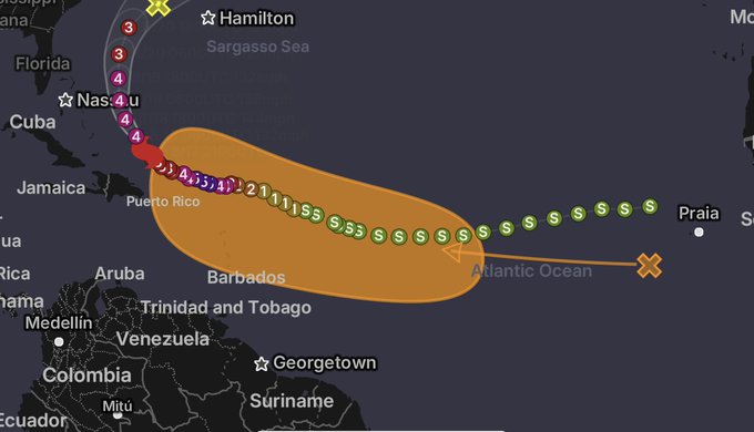
🌀 Tropical Wave Development - West of Cabo Verde Islands
This article reports on the medium chance of tropical development associated with a tropical wave west of the Cabo Verde Islands. The disturbance's projected path and potential land impact are discussed.
Key Points:
• Medium chance of tropical development this week.
• The wave will move westward, passing over the Lesser Antilles this weekend.
• Ongoing monitoring for potential land impact.
🔗 Resources:
Image

Image
• Matthew Cappucci ↗ - Tropical weather analysis and forecasting
🌀 Tropical Storm Potential - Following Hurricane Erin
This article discusses the increasing potential for a new tropical storm to form behind Hurricane Erin within the next 7 days. The potential impact and intensity are discussed.
Key Points:
• Increased potential for a new tropical storm to form.
• This system has a higher chance of impacting land compared to Erin.
• It may be less intense initially due to Erin's impact.
🔗 Resources:

Image
• Max Velocity WX ↗ - Tropical weather analysis and forecasting
⚡️ US Virgin Islands - Storm Impact and Power Outages
This article reports on the impact of a recent storm in the US Virgin Islands, specifically focusing on high winds and power outages.
Key Points:
• Winds reached 58 mph (94 km/h) in St. Thomas.
• Significant rainfall (4+ inches) occurred.
• Widespread power outages affected the US Virgin Islands.
🔗 Resources:

Image
• John Morales ↗ - Reporting on storm impacts
🔥 Wildfires - US-Canada Border and Climate Change Collaboration
This article discusses worsening wildfires north and south of the US-Canada border, emphasizing the need for collaboration on climate change solutions.
Key Points:
• Worsening wildfire situation along the US-Canada border.
• The need for joint climate change solutions is highlighted.
• A continuing trend of warming and drying conditions exacerbates the problem.
🌀 Atlantic Wave Analysis - EURO, GFS, and CMC Ensemble Forecasts
This article analyzes ensemble forecasts from EURO, GFS, and CMC models for an Atlantic wave, focusing on timing and directional trends.
Key Points:
• Ensemble forecasts provide insights into timing and direction of an Atlantic wave.
• EURO model shows more activity in the Atlantic, with many curving paths.
• GFS shows a mix of curving and westward paths.
🔗 Resources:

Image
• Tropical Tidbits ↗ - Tropical weather analysis and forecasts
🌀 Outer Banks Forecast - Hurricane Proximity and Wind Speeds
This article discusses a hurricane's projected path and its potential impact on the Outer Banks, focusing on wind speeds and proximity.
Key Points:
• GFS model aligns with other guidance.
• Closest approach to the Outer Banks is still 84 hours away.
• Potential for 55-65 mph winds on the Outer Banks.
⭐️ Support
If you liked reading this report, please star ⭐️ this repository and follow me on Github ↗, 𝕏 (previously known as Twitter) ↗ to help others discover these resources and regular updates.
