This article provides an overview of live radar data from EEC, detailing current shower and storm activity across Florida. It highlights the potential for some storms to become strong this evening.
Key points
• Access live radar data to monitor ongoing weather conditions.
• Track showers and storms as they move across Florida.
• Identify areas where storms may intensify to strong levels.
• Stay informed with real-time updates from official weather sources.
Sources
TMainolfiWESH - Source for local weather updates
Florida Hashtag - Related discussions on Florida weather
WESH - Official local news channel for updates
WESH WX Hashtag - Weather-specific updates from WESH
Environmental Policy - Endangerment Finding Challenges
This article discusses historical challenges to the 2009 Endangerment Finding, including motions filed with the DC Circuit and the court's response. It also addresses the new rule revoking the finding and associated petitions for reconsideration.
Key points
• Legal challenges were filed against the 2009 Endangerment Finding.
• A motion for judicial notice was presented to the DC Circuit.
• The court did not accept the motion for judicial notice.
• A new rule has been enacted, revoking the original Endangerment Finding.
• Petitions for reconsideration from 2010 and 2022 are being granted.
Sources
RyanMaue - Source for related discussions
HarryMacD - Source for detailed information on challenges
ClimateAudit - Source for environmental policy insights

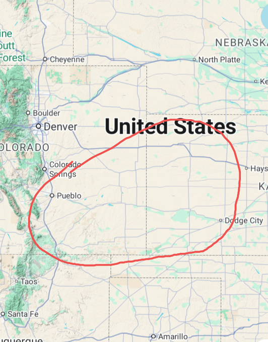
Weather Alert - Dangerous Fire Conditions
This article outlines a severe weather alert from NWS Pueblo, Goodland, and Dodge City, indicating a potentially dangerous situation for Tuesday. It details the risks associated with extremely dangerous fire conditions.
Key points
• NWS offices indicate a potentially dangerous situation.
• Extremely dangerous fire conditions are anticipated for Tuesday.
• Any new fires could experience explosive growth.
• Fires may be nearly impossible to contain once started.
Sources
- AnubizzzBurner - Source for weather alerts
Weather Warning - Lake County Thunderstorm
This article provides an urgent weather warning for a severe thunderstorm impacting Lake County. It details the duration of the warning and the projected wind gust speeds.
Key points
• A Severe Thunderstorm Warning is active for Lake County.
• The warning is issued until 8:15 PM EST.
• Wind gusts are expected to reach up to 60 Mph.
Sources
- EricBurrisWESH - Source for local weather warnings
Weather Statement - Florida Regions
This article details a special weather statement issued for Homosassa Springs FL, Hernando FL, and Citrus Springs FL. It specifies the duration of this alert for public awareness.
Key points
• A special weather statement has been issued.
• Affected areas include Homosassa Springs FL, Hernando FL, and Citrus Springs FL.
• The statement is valid until 6:45 PM EST.
Sources
- NWSTampaBay - Source for local weather statements

Weather Alert - Central Florida Thunderstorms
This article provides an alert regarding strong thunderstorms expected to impact several counties in Central Florida. It specifies the affected areas, duration, and projected wind gust speeds.
Key points
• Strong thunderstorms are expected to impact specific counties.
• Citrus, northwestern Sumter, and northwestern Hernando counties are affected.
• The impact is expected through 6:45 PM EST.
• Wind gusts are predicted to be between 40 to 50 Mph.
Sources
- EricBurrisWESH - Source for local weather alerts
Maritime Weather - Gulf Coast Advisory
This article details a Special Maritime Advisory for specific coastal and offshore waters along Florida's Gulf Coast. It outlines the affected regions and the duration of the advisory.
Key points
• A Special Maritime Advisory has been issued.
• It covers coastal waters from Tarpon Springs to Suwannee River FL, out 20 NM.
• It includes offshore waters from Tarpon Springs to Suwannee River FL, out 20 to 60 NM.
• The advisory is effective until 7:00 PM EST.
Sources
- NWSTampaBay - Source for maritime weather advisories
